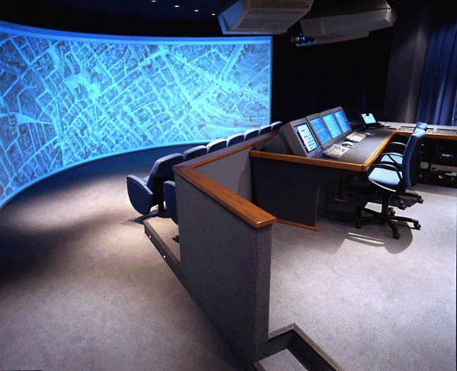
Figure 1 : Il Teatro Virtuale of CINECA at Bologna (Italy)
Presentation
of
«
Virtual flight on large geographical and environmental data bases »
in
the Reality Center of CINECA at Bologna
Wednesday
17 January 2001
Pierre Aurousseau, Professor, Laboratory
of Spatial Data,
ENSAR, 65 rue de Saint Brieuc, 35042
Rennes cedex, France.
Tel : 33 2 23 48 54 28, Fax : 33
2 23 48 54 30
e-mail : carto@arthur.roazhon.inra.fr
Hervé Squividant, Information
Technology Engineer, Laboratory of Spatial Data,
ENSAR, 65 rue de Saint Brieuc, 35042
Rennes cedex, France.
Tel : 33 2 23 48 52 32, Fax : 33
2 23 48 54 30
e-mail : squivid@onyx.roazhon.inra.fr
1 The concept of Reality Center
Introduction : The several types of reality centers : curve, workbench, cave
The main components of a curve reality center : (1) the computer (real time 3D graphic computer called virtual reality computer), (2) the video-projector apparatus, (3) the screen, (4) stereo-visualisation, (5) high resolution images
Figure 1 : Il Teatro Virtuale of CINECA at Bologna (Italy)
2 The aim of the project
The aim of the project is to reconstruct with the greatest possible precision a landscape that can be observed in virtual flight as if from an aeroplane or helicopter and to carry out flights over large geographical and environmental databases in one continuous pass.
Thus, the aim is to enable the user of the geographical and environmental database to consult the information in virtual flight mode. A known flight altitude is chosen and the user is free to move virtually within this plane above the database. From the chosen flight altitude, the user can observe the database from any convenient angle of view. At any moment, the virtual flight altitude can be modified, but, in contrast to a flight simulator, there is no link between the viewing direction and the direction of flight.
Finally, the user is not simply placed in the situation of an observer. He or she is able to make pinpoint interrogations of the geographical database. To achieve this, the user activates a graphical operator simulating a missile fired from the viewing point, which makes it possible to interrogate the database at the point targeted on the ground.
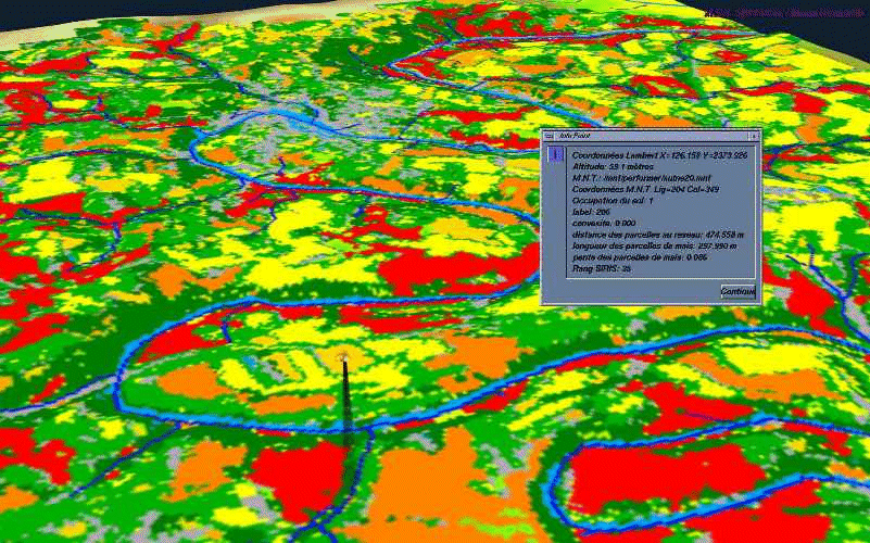
Figure 2 : a graphical operator simulating
a missile is fired from the viewing point.
It makes it possible to interrogate
the database at the point targeted on the ground
and some of the informations available
in the database are displayed in an alpha-numeric window.
The applications are made up of two shells of information : (1) a terrain database which describes the relief of the studied area and (2) one or more textures which are draped over the terrain database and which are viewed during the virtual flight.
To obtain great
performances in real time 3D display, in applications of virtual flight,
it is necessary on one hand to have extremely powerful computers but it
is also necessary on the other hand to implement a whole panoply of methods
of optimisation. These methods of optimisation are related as well to the
base ground (the description of the relief) than to the display of textures.
3 The terrain base
The terrain database is generated from Digital Elevation Models (DEMs), which are geographical databases describing the actual relief of an area. The DEMs are in the form of a regular grid having square cells whose points are known in terms of geographical and elevation coordinates. On another hand, terrain databases are in form of triangular cells whose smallest cells are the result of division of the original square cells of the DEM in two parts. Several optimisation techniques are implemented to allow virtual flights over large-sized databases : a static optimisation technique (the LOD or Level of Detail Technique) and a dynamic optimisation technique (the ASD or Active Surface Definition technique).
The stages of the preparation of the base ground are the following ones: starting from the MNT with square cells (fig. 2 A),
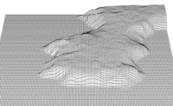
Figure 2 A : Various stages of the
preparation of a base ground and a texture.
Example starting from an extract
of 128 X 128 cells of the DEM of Brittany with 20 meters cell size.
We produce first a description of the ground in the form of facets (fig. 2 b).
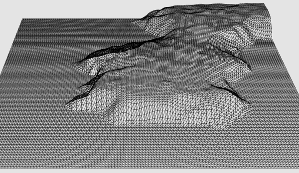
Figure 2 B
Then the techniques of optimisation are implemented. Static optimisation consists in describing the base ground with facets all the more small since the relief is accentuated : the smallest facets correspond to the resolution of the available DEM (20 meters in our case for the DEM of Brittany). In the plane zones or with weak relief, non-relevant information is abandoned to manage only larger facets of 40, 80 meters, or any multiple of the maximum resolution by a power of 2. It is the technique of the Levels of Detail (LOD) (fig. 2 C).
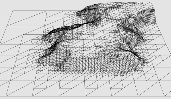
Figure 2 C
The dynamic optimisation technique called Active Surface Definition (ASD) consists in displaying a level of detail according to the distance between the object and the observer. In the back ground we display only the lowest level of the detail available. In the first ground we display the highest level of detail available. The software displays continuously from a given level of detail to the following level of detail by continuous transformation of the image (morphing) (fig. 2 D and 2 E).
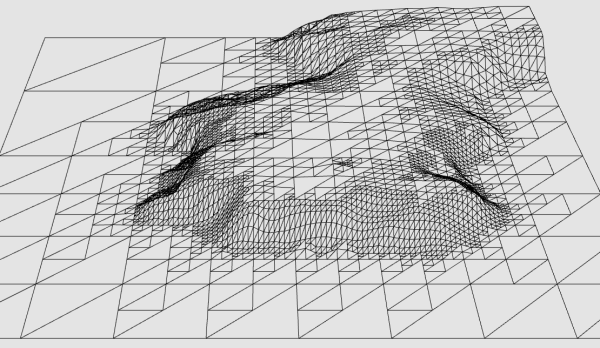
Figure 2 D
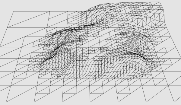
Figure 2 E
Active Surface
Definition (ASD) are managed in the form of tree : a facet of level 1 points,
if the relief of the ground justifies it, on four facets of level 2 which
themselves points, if the relief of the ground justifies it, on four facets
of level 3 and so on (see figure 3 which details an example of 2 cells
of 160 m size, divided into 4 facets of level 1 and ... 40 facets of level
4 whose size reaches the maximum resolution of the DEM, i.e. 20 meters).
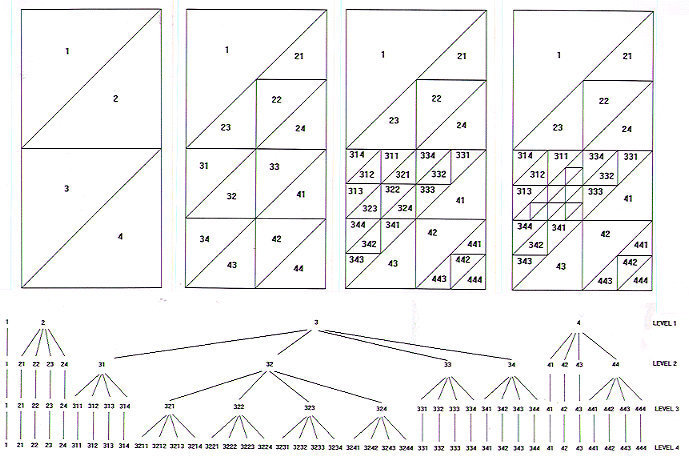
Figure 3: Use of active surface definition
(ASD).
Example of two cells of 160 meters
size.
At a given distance
from the observer the software displays a level of resolution (for example
level 2). The ground is then displayed at the highest possible level of
resolution (inferior or equal to level 2) permitted by the tree which manages
the Level of Detail. When the observer approaches the software displays
the following level of detail.
4 The overlaid textures
The overlaid textures can be made up either of untreated aerial or satellite images, or processed images (classified in terms of land use, for example), or may correspond to geographical and environmental data that have been processed or produced by a Geographical Information System (GIS). Optimisation techniques need also to be used for texture management : the mipmaping technique (mipmaps, virtual mipmaps, dynamic mipmaps, insets).
In any given application used with the same terrain database, several textures are pre-loaded corresponding to different types of environmental information. During the flight, it is possible to switch instantaneously from one texture to another.
For the optimisation of the display of textures, techniques of same type are implemented : texture is tiled and tiles with variable resolution are prepared and pre-loaded : tiles with maximum resolution (a pixel image for a pixel screen) and tiles with degraded resolution (four image pixels for one screen pixel and so on).
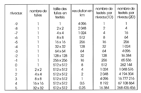
Table presenting the mipmap of the
data base of Europe ( 4096 X 4096 km with a resolution of 250 m on the
ground).
This multi-resolution mipmap is
described with 15 levels of resolution (from -9 to +5).
On level +5, texture consists of
32 X 32 tiles of 512 X 512 textels of 250 metres size that is to say more
than 268 Mtextels.
With the other extreme, on the level
-9 this texture is described in the form of only one textel of 4096 km
size.
It is interesting to notice that more the techniques of virtual reality evolve more the format of the data evolves and moves away from the traditional formats used in image processing and geographical information systems : more and more advanced formats are implemented in the objective to improve the data-processing performances and the performances in 3D display.
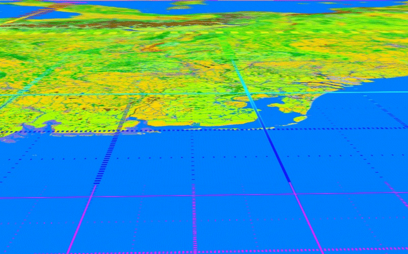
Figure 4 : A multi-resolution view
of Europe from the North towards the South.
In the first ground the North Sea
; in the second ground Netherlands,
in the third ground Germany and
then the Alps, Italy and in the back ground
the Mediterranean Sea with Corsica
and Sardinia in the centre and the Adriatic Sea on the left.
On the right France and in the back
ground Spain and Balearian islands.
The overlaid stripes indicate the
level of resolution of this multi-resolution image.
The pink colour of the stripes of
the first ground indicates a 250 m resolution ;
the blue stripes indicate a 500
m resolution ; the pale blue a 1 km resolution ;
the green a 2 km resolution ; the
yellow stripes indicate a 4 km resolution
and the red a 8 km resolution in
the back ground.
The size of the tiles are also displayed
in this image.
5 Several families of virtual flight applications
Several families of applications have been developed covering different types of environmental information to be conveyed, involving databases of variable size and resolution.
5.1. Virtual flight over France and Brittany : agregation of nitrogen budget at watershed level
The data base is 1024 x1024 km large with a 250 m resolution, then the original texture size is 4096 x 4096 textels (about 16 Mtextels). Main environmental message is : the 94 watersheds larger than 2000 ha of Brittany process by DEM treatment, main hydrographic network also processed by DEM treatment, apparent nitrogen budget at the level of administrative units (1365 communes of Brittany), aggregation of these budgets at watershed level (in fact by use of the tau operator, presented in September at Ispra, aggregation is available for each cell of the DEM). By use of the pin-point interrogation graphic operator (missile shot from the view point) interrogation of the data base is available for each cell of the DEM.
5.2. - Virtual flight over Europe : hypsometry, Corine land cover and hydrographic network
The data base is 4096 x 4096 km. The terrain base is derived from a DEM of Europe with 500 m cell size, itself being the result of resampling of a DEM of Europe with 30 seconds arc cell size. Two textures are used : an hypsometric texture (Figure 5) with 500 m resolution (more than 67 Mtextels) and a texture produced from 250 m resolution CORINE LAND COVER raster data base (more than 268 Mtextels). All these data bases are in an Lambert Azimuthal projection system slightly different from the CORINE Lambert Azimuthal projection system. The original CORINE Lambert Azimuthal projection system has been defined when EC included only six countries and the tangential point of the projection system was near the geographic barycentre of the six countries (not far from Strasbourg). We have defined a new Lambert Azimuthal projection system taking in account the evolution the the European Community and the new tangential point is more towards the North-East to minimise geometric deformations incoming from the projection system. A data base of the hydrographic network has been also introduced in the textures (this date base has been produced from Digital Chart of the World). About one hundred city names has been also added. Using the pin-point interrogation graphic operator, one can display in an alphanumeric window the CORINE LAND COVER class of the shot textel.
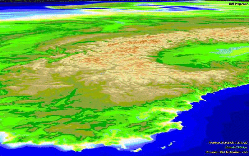
Figure 5 : View of Europe from the Mediterranean Sea towards the North
5.3. Land use and risk of water contamination by pesticides
The data base is 10 x10 km large with a terrain base derived from the DEM of Brittany with 20 m cell size. Two main textures can be displayed : a 10 m texture derived from a panchromatic SPOT image of the area and a 20 m colour texture including two kinds of informations (a land use information with six land use classes : maize (1), wheat (2), grassland (3), forest (4), mineral = roads and buildings (5), water (6) and a risk index of water contamination by pesticides which has been calculated for all maize plots). This risk index values start from zero up to 160. This risk index takes in account five risk factors (hydraulic distance of the plot towards the hydrographic network, slope of the plot, length of the plot, concavity-convexity, land use protecting the hydrographic network). These five risk factors has been combined with an hierarchical mathematic method (SIRIS method) to obtain a final risk index.
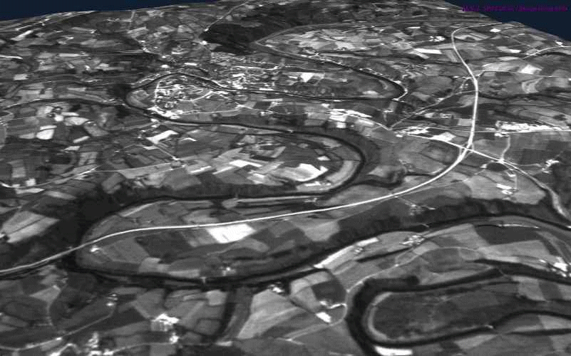
Figure 6 : View of the Aulne
drainage basin in the Chateaulin area (panchromatic SPOT image with 10-m
resolution).
The meanders of the Aulne River
can be seen as well as the dual-carriageway road between Quimper and Brest,
and, further in the distance, the
town of Chateaulin.

Figure 7 : View of the Aulne drainage
basin in the Chateaulin area (land use is shown using a texture made up
of 20-m colour pixels).
Pinpoint interrogation is carried
out on maize plot (land use code = 1) with a low risk
of water contamination by pesticides
(low order risk, SIRIS index = 28) displayed with light orange colour code
.
5.4. Land use and risk of water contamination by pesticides
The data base is 40 x 40 km large with a terrain base derived from the
DEM of Brittany with 20 m cell size. Two textures are displayed : the first
one is a mosaic of more than one hundred aerial images and the second displays
the land use within the waterlogged areas of bottom land.
5.5. Virtual flight using detailed textures
The data base is 10 x 10 km large with a terrain base derived from the DEM of Brittany with 20 m cell size. A detailed texture has been realised from a mosaic of about 15 aerial images which have been digitised with 2.5 m resolution.
Detailed textures can be realised either from detailed satellites images
with 1 m meter resolution which are available (Ikonos and Orbview satellites)
but the prices of such images are still very expensive. Some geographic
institutions propose also detailed data base produced from aerial images
with a rather competitive price. For example IGN produce now a data base
called BD Ortho with 0.5 m resolution at about 150KF or 20 000 Euros for
one administrative department (between 5000 and 7000 km2). But it will
take a few years to produce these data for all France. The produced textures
have also a huge size : for example for half of Brittany the texture would
be more than 68 Giga textels and more than 210 Gigabytes.
5.6. Sub-watersheds contours, hydrographic network and waterlogged areas of bottom land
The data base is 40 x 40 km large with a terrain base derived from the DEM of Brittany with 20 m cell size. The texture is realised from a panchromatic SPOT image and modelled geographic informations.
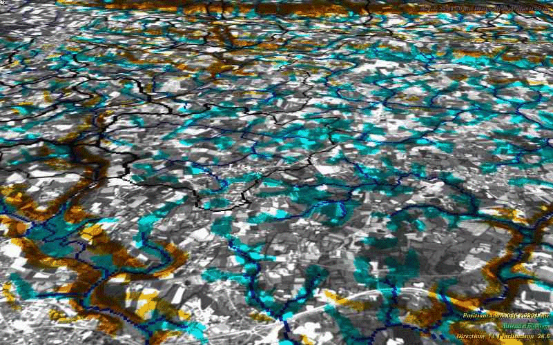
Figure 8 : View of the Loc'h drainage
basin.
Image extracted from virtual flight
over the Loc'h drainage basin (catchment area of about 30 000 ha draining
into the western part of the Golfe du Morbihan near Auray : south of Brittany).
The database is made up from a Digital
Elevation Model with a 20-m step.
The texture is formed of a panchromatic
SPOT image with 4096 x 4096 textels measuring 10 m on each side, which
is added to the color information composed of 1024 x 1024 textels measuring
40 m on each side derived from processing by a Geographical Information
System.
This database is established within
the Lambert II geographical projection system.
Geographical and environmental information to be conveyed : the drainage
basin of the Loc'h and its division into sub-basins is in conformity with
a network of points for water quality monitoring. Visualisation of the
drainage network is modelled by DEM processing. Also shown is the extent
of water-saturated bottomlands, zones which are susceptible to denitrification
processes (cf. role of these waterlogged zones in the transfer of pesticides
and heavy metals) as well as the location of steeply sloping areas which
are subject to runoff risks in terms of nitrogen, phosphorus and pesticides.
6 Numerical movies
Numerical movies can be realised during virtual flight applications. In a short future it shall be numerical movies in MPEG2 format with a resolution of 720 x 576 pixels stored in DVD-ROM which allow up to 4.7 Go of data and up to 160-240 minutes of movie.
Up to now, we are able to produce numerical movies in MOV format stored in CD-ROM. The MOV format does not allow a compression as efficient as in MPEG2 format and the capacity of CD-ROM which is more than 6 times less than in DVD-ROM allow to store only between 5 and 9 minutes movie with a refresh rate of 25 frames per second (and between 8 and 15 minutes with a refresh rate of 15 frames per second).
When we produce
numerical movies, we do not reach any longer the same quality and resolution
than during virtual flight in a reality center :
- interactivity is lost : a fix movie is stored either in the CD-ROM or
in the DVD-ROM ;
- high resolution is lost : for example we have any longer the standard
high resolution available in a reality center (3600 x 1024 pixels with
a refresh rate of 96 frames per second) but the usual PAL resolution (720
x 576 pixels with a refresh rate of 25 frames per second). Sometimes the
refresh rate can be lower for capacity reasons (for example 15 frames per
second) ;
- stereo-visualization is lost ;
- some important functionalities are lost as the pin-point interrogation
operator and the display of alpha-numeric informations coming from the
data base. But this point can be solved by other technical solutions than
the solutions available at this moment in our laboratory.